A Tour Through The North Georgia Mountains
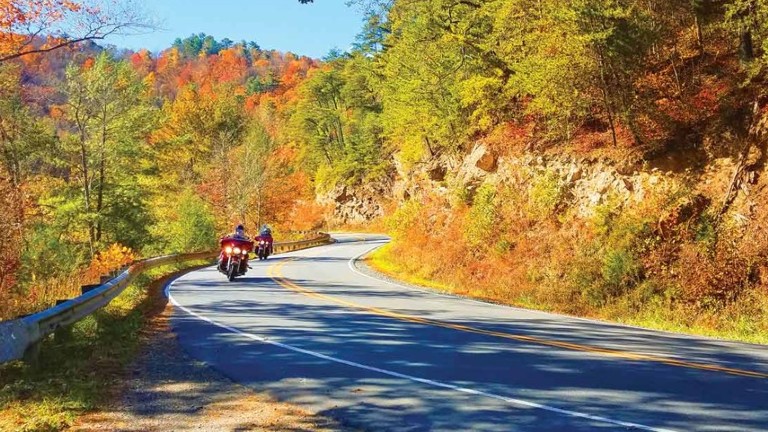
Local riders rave about motorcycle roads in North Georgia. If you’re surprised, then you probably aren’t from these parts. No problem. This scenic three-day tour shows off some of the best motorcycle roads and well-known destinations in northern Georgia. You’ll want to put this tour on your short list.
Starting in the capital city of Atlanta, the ride takes a wide loop north through the Chattahoochee National Forest stretching into North Carolina where it then turns south to follow the Savannah River on the South Carolina side. Turning back into Georgia, the ride runs through Augusta and then on to Atlanta. Ride time and miles are comfortable for virtually any rider, leaving plenty of time to enjoy small towns and sights along the way. The combination of Georgia country roads and Appalachian Mountain twistiness makes this a must ride for any motorcyclist.
What to Expect
Riding in Georgia can best be described as relaxingly picturesque. The roads have a southern feel; narrow with slight shoulders and shrouded in Georgia pines and oaks. Twists come in bursts separated by relaxing stretches through quiet forest and wide meadowlands. Elevation changes are gradual and extend over miles never seriously challenging a competent sport touring rider. Sky Valley, the highest point on this ride and the highest town in Georgia, has an elevation of only a little more than 3100 feet.
Weather in Georgia can change quickly. Summer temperatures are in the upper 80’s with characteristic southern humidity making it feel even warmer. Hard short rains often come in the afternoons along with the potential for lightening. Always check the forecast before setting out and gear-up accordingly. As on any ride, easily removed layers are recommended for quick adjustments to accommodate changing conditions.
Roads on this tour are all paved. However, many roads in Georgia (and the Carolinas for that matter) feature an abundance of tar snakes which can become slippery when wet and when softened up in a hot sun. Unexpected gravel or sand kicked up from adjoining driveways is also a regular risk given. Take sensible precautions when riding unfamiliar roads.
With so many small towns along the way, there are plenty of local coffee shops and cafes to choose from.
Atlanta to Helen Through The Chattahoochee National Forest
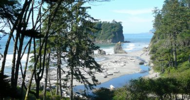
This first day of riding features some of North Georgia’s best motorcycle roads in the famed Chattahoochee National Forest with stops in picturesque towns including Ellijay, Blue Ridge, and Helen. But first one must escape the congested city of Atlanta.
Most people agree traffic in the greater Atlanta area is just plain bad. To avoid spending a good part of the riding day in traffic leave Atlanta for Braselton on US-85 as early as possible. From there the roads improve steadily with the best parts coming after Gainesville. The woodsy run along GA-52 between the junction with GA-136 and Ellijay offers a short respite from rural scenery, but better roads lie ahead.
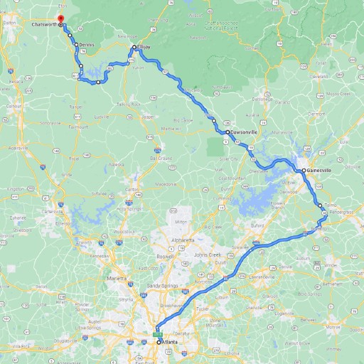
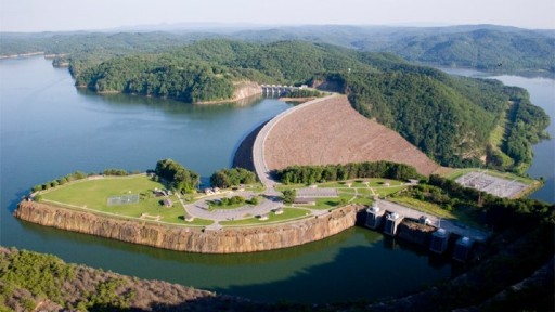
Follow GA-382 to GA-136 to loop around the south end of Carters Lake and the Reregulation Reservoir. While not on the main tour route, a stop at Carters Lake Visitor Center is only a little more than 2 miles off GA-136 on Carters Dam Road. Information about the history of Carters Lake, the dam, and the surrounding area are all on display. Views of the dam itself, the largest earthen dam east of the Mississippi, are available from multiple vista points near the Visitor Center.
From Carters Lake ride up to Chatsworth past Dennis along the edge of the Chattahoochee National Forest. Chatsworth sits at the entrance to the Appalachian Mountains in northwest Georgia. With plenty of restaurant options Chatsworth makes an ideal lunch stop before heading into the forest.
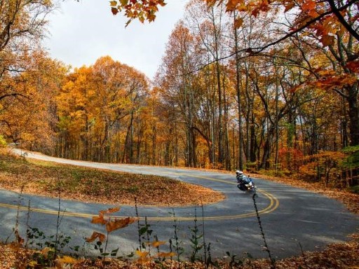
Leave Chatsworth on GA-52. The first 12 miles comprise a section of the Cohutta-Chattahoochee Scenic Byway and arguably are the most enjoyable section of the byway’s 54 miles. This noteworthy road winds up and down through the Chattahoochee National Forest offering picture-worthy vistas of rolling hills and the Cohutta Mountains. Take in gentle curves separated by pockets of attention getting 25MPH twisties.
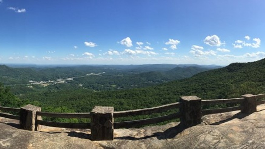
The Fort Mountain Overlook, although not marked, is easy to spot and a recommended stop. The views to the valley and mountains are inspiring. A loop through Fort Mountain State Park just a little farther up the road provides even more views of the Cohutta Mountains and the possibility of spotting a black bear. The area around the park was once home to Cherokee Indians where it’s believed they constructed a stone wall near the crest of the mountain. Some historians argue the wall was built by the Cherokee to defend the area while others say it served a spiritual purpose.
Another 5 miles or so up the road, look for the Cohutta Overlook. Pull in to take one more look at the panoramic views of the wide valley and Cohutta Mountains below. The overlook is off the highway and easy to miss – watch for the US Forest Service sign on the left that marks the entrance. Cohutta Overlook also marks the end of the scenic byway, but more good riding lies ahead on GA-52 as it twists and turns through the Cohutta Mountains.
Follow GA-52 to Ellijay, known as the Apple Capital of Georgia with its surrounding orchards. Plan a ride in the fall to enjoy fresh apples from pop-up fruit stands dotting the roadside.
Turn north on Old Highway 5 toward Blue Ridge. This unremarkable highway takes the ride to Old US Highway 76 on the north end of Blue Ridge Lake and then continues to GA-60.
Blue Ridge is a popular mountain get-away in the Chattahoochee National Forest. The town offers an assortment of craft breweries, restaurants, and other tourist activities. One of the most popular attractions being a 4-hour scenic train ride in the southern Appalachian Mountains along the Toccoa River to the town of McCaysville on the Georgia-Tennessee state line.
Shortly after crossing the Blue Ridge Dam the highway becomes GA-60 and so begins another of Georgia’s best motorcycle roads. Sections of this road are positively enchanting with well-spaced tight curves and crowded shoulders framed by the Chattahoochee National Forest on either side. The pace continues through Suches and past Woody Lake. This is Georgia high-country albeit at a relatively modest elevation under 3000 feet.
Georgia riders refer to the roads around Suches as “Georgia’s Tail of the Dragon”. In fact the “dragon” is a triangular loop stretching from Suches southeast on GA-60 to US-19, then north on US-19, and then returning to Suches on GA-180. The tour described in this article covers the first two segments of the loop, but not the return to Suches. Some might argue GA-180 is the best part of the ride. Feel free to turn left on GA-180 at Suches to find out. This tour opts to cover two of three sections and leave the last, GA-180, for another time.
The pullout at Woody Gap, past Suches, is worth a stop for panoramic views of the North Georgia Mountains and the Yahoola Valley from an altitude of 3160 feet. Beside picture-worthy vistas, Woody Gap also marks where the historic Appalachian Trail crosses Georgia’s Blue Ridge District.
Keep an eye out for US-19 about 7 miles down the road from Suches where the ride turns north. US-19 is another masterpiece of Georgia motorcycle roads running though yet more of the Chattahoochee Forest. Vogel State Park along the way is one of the oldest parks in Georgia situated at 2500 feet above sea level in the shadow of Blood Mountain, the highest summit on the Appalachian Trail in Georgia.
Turn off US-19 east on GA-180 and then take GA-348 to Helen. GA-348, also known as the Richard B Russell Scenic Byway, brings the riding day to an end with flair. The road throws an array of splendid curves, corners, and twists that are sure to be discussed over dinner.
A few pullouts, in particular the Dodd Creek Vista point, offer picture taking opportunities of the surrounding mountains and valleys. For Appalachian Trail buffs, the historic Walasi-Yi Inn on US-19 marks a noteworthy trail crossing. This is the only point where the 2175-mile Appalachian Trail literally passes through a man-made structure, earning the Walasi-Yi Inn a place on the National Register of Historic Places.
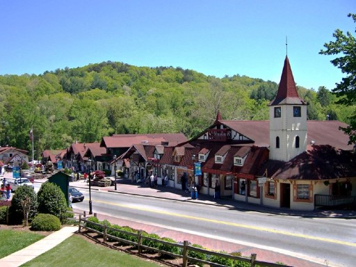
At the next junction, take GA75A to GA-75 into Helen where the day ends. Helen is one of Georgia’s most popular getaway destinations. Themed as a Bavarian-style town, Helen is filled with shops and restaurants of all kinds and a selection of comfortable accommodations. If time allows, consider spicing up the day with tubing or zip lining. Helen is known for outdoor activities.
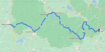
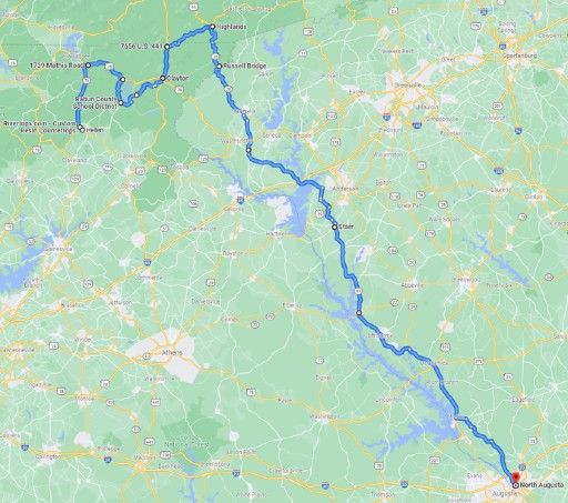
Helen to Augusta Through the Carolinas
The second touring day begins in Helen, following a meandering northerly route, continuing through the Chattahoochee National Forest into North Carolina before cutting across the northeast corner of Georgia into South Carolina where the ride arrives in Augusta at the end of the day.
Leave Helen on GA-17, the final section of the Richard B Russell Scenic Byway, heading north toward Macedonia. This quiet 2-laner is flanked by hills and trees with the Chattahoochee River running alongside the road. The riding is easy for the most part, with a few curvy stretches here and there.
At Macedonia, take GA-2 to US-76 heading east. Initially an unremarkable road, eventually US-76 crosses the Appalachian Trail and from that point begins to develop a more exciting personality. Make a stop at Popcorn Overlook to capture views of the North Georgia mountains.
Rather than continue on US-76 to Clayton we chose a more interesting path. Look for the junction with GA-197 about a half mile past Popcorn Overlook. This road is decidedly more twisty as it winds south past Lake Burton. At the south end of the lake, take Burton Dam Road east around the south end of the lake and then connect with Bridge Creek Road heading north again, eventually arriving in Clayton. The fun-factor on this detour is absolutely worth the extra 24 miles.
The planned route bypasses the scenic town of Tallulah Falls. For those who would like to experience this popular destination, take Seed Lake Road off Burton Lake Road for 12 miles to US-23. Tallulah Falls is about 4 miles farther south. The town of Tallulah Falls overlooks Tallulah Gorge which itself features a series of six stunning waterfalls and many hiking trails. Tallulah Point Overlook is a favorite stop, offering views of the gorge and a gift shop. Ride back to Clayton on US-23 to resume the planned route.
At Clayton, pick-up US-23 toward North Carolina. At the small town of Dillard turn onto GA-246 eastward to Highlands North Carolina. The road packs a good number of fast turns as it dips in and out of North Carolina before dropping south to Sky Valley Overlook. At an elevation just under 3300 feet, Sky Valley is one of the higher points on the ride, but not the highest. The view from the overlook down to Sky Valley shows an expanse extending from valley to forest to distant mountains.
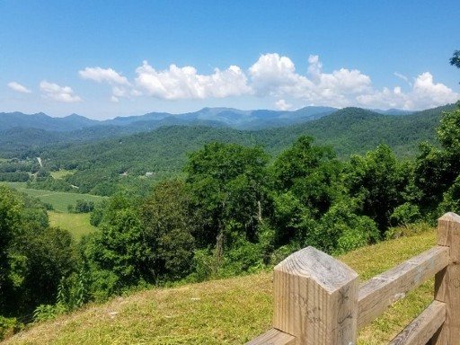
Not long after Sky Valley Overlook, GA-246 enters North Carolina where It becomes NC-106 quietly passing through the Nantahala National Forest and occasional ranch land. There are several worthwhile overlooks along the way offering even more photo opportunities. If you have time for only one, try the Blue Valley Overlook. The views are wide and endless. This is definitely a fun mountain road for motorcycling and a popular area for outdoor recreation. It’s narrow and twisty enough to keep any rider smiling.
Continue on NC-106 across the south end of Lake Sequoyah and into Highlands North Carolina. The small town of Highlands sits on a plateau in the Appalachian Mountains at an elevation of just over 4100 feet surrounded by the Nantahala National Forest. With a small population of less than 1000, Highlands has yet to become the crossroads of trade between east and west that the founders envisioned in 1875. Still, a nice stop for lunch or coffee.
Continue south, this time on NC-28 toward Georgia. There are some fun sections as the road descends to the state line and rolls into Georgia toward Pine Mountain. A short distance past Pine Mountain, GA-28 crosses the Chattooga River into South Carolina and becomes SC-28. The ride on the South Carolina side of the river is loaded with wide turns along a road closed in on both sides by a variety of pine trees and other native species.
If time permits, consider a stop at Stumphouse Park for a cool-down in the Stumphouse Mountain Tunnel. This tunnel was started before the Civil War but never completed. With a constant temperature of 50 degrees Fahrenheit Clemson University had used the tunnel to grow blue cheese for 20 years into the early 1970’s.
Eventually SC-28 rolls into Walhalla where the ride turns onto SC-183 and then SC-11 heading south. The road twists and turns as it runs south more or less following the Savannah River to the west. The scenery is intermittently marked by small towns tucked between stretches of relaxing tree covered roads.
Keep riding south toward Starr South Carolina, then on to Calhoun. Unfortunately stops aren’t allowed on either side of the bridge that crosses Lake Hartwell; the view in either direction is incredible.
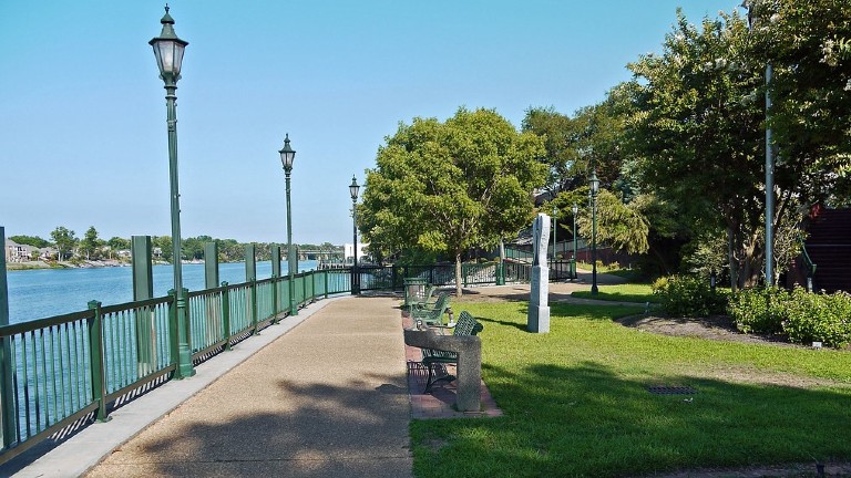
Augusta is a good size city on the Savannah River in Georgia. Together with North Augusta on the South Carolina side the region is collectively known as the greater Augusta Georgia Metropolitan Area. The historic Augusta downtown is in the City of Augusta on the Georgia side of the river. There you can find a wide choice of restaurants and accommodations. In addition to good dining, highlights in Augusta include the Augusta Historical Museum and the Augusta Riverwalk Park. All in all, a comfortable end to the second day of this tour.
West to Atlanta from Augusta
After two days riding in North Georgia forests and mountains, this last day of riding takes a less exhilarating route, but with some good scenery nonetheless and a few interesting bits of pavement as well.
Leave Augusta on US-78 westbound toward Atlanta. This part of the day is about as uninteresting as they come, but keep the faith. The ride gets better after the first 20 miles or so, just west of Harlem when the road narrows to a two-lane highway lined on either side by a mix of Georgia pines and maples. Follow US-78 to Bearing and watch for Hobbs-Mill Road just past town toward Happy Valley. The road passes unhurried through crop fields and ranch land separated by pockets of trees scattered here and there.
At Happy Valley, connect with GA-17 and then turn west on Happy Valley Road. Happy Valley Road is rural, two lanes, and perfect for relaxing and taking in the views of central Georgia. It’s not a twisty road, but somehow just right for riding. Watch for Jewel Road, where the ride turns right eventually connecting with GA-16 which then leads to Sparta.
The town of Sparta was incorporated in 1805 and earned its name for the resolute bravery of its pioneering townspeople reminiscent of the ancient Greeks. Later, during the Civil War, Sparta was at the crossroads of conflict. The courage of its citizens once again saved the town from harm. Today, Sparta welcomes visitors offering a fine assortment of local restaurants perfect for a mid-day meal or late morning coffee.
From Sparta, follow GA-22 to Milledgeville, another Georgia town of historical significance. Milledgeville, named for John Milledge the 26th Governor of Georgia, was once the state capital owing to the cotton boom, its location on the Oconee River, and prosperous trade with Savannah down-river. Today, the town stands as a rich reserve of early American antebellum architecture reflecting the pre-war period between the American Revolution and the Civil Wat.
From Milledgeville, follow GA-212 toward the Cedar Creek Wildlife Management Area in the Oconee National Forest. The Cox-Mathis House, near the Cedar Creek Check Station is notable; built by a Revolutionary War veteran and believed to have been used by General Sherman’s troops on their march to Savannah.
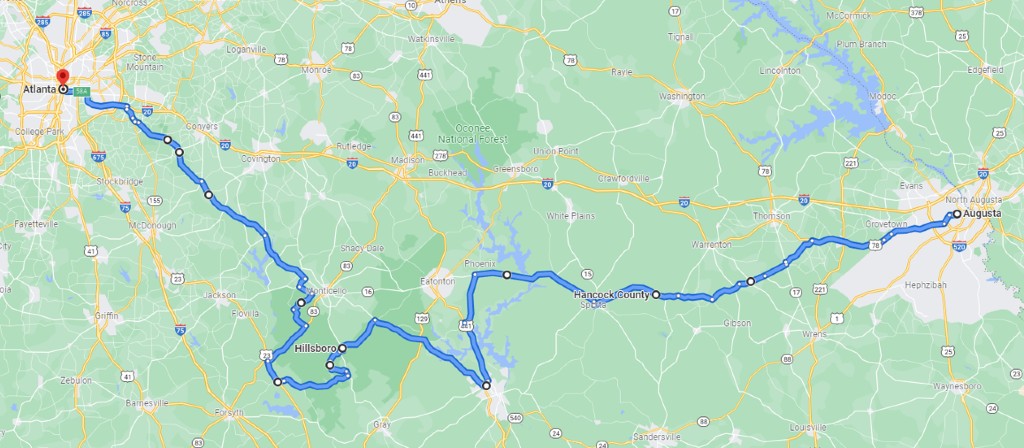
Turn left off GA-212 at Fullerton-Phillips Road heading south through the Oconee Forest. These roads through the forest are not particularly twisty, but the solitude and scenery are fantastic. At Hillsboro, recognizable by the large cemetery that seems to consume the whole town, turn left on GA-11 and then right onto Sugar Hill Road. Eventually re-connect with GA-11 heading South and then take Round Oak Juliette Road west through the Piedmont National Wildlife Refuge.
The Piedmont refuge is a 35,000 acre area to the south of the Oconee National Forest that was reclaimed and managed to health after forests were clearcut to make way for cotton farming only to be abandoned during the Great Depression. Learn more about the area at the Visitor Center on Allison Lake Road. Keep in mind that many side roads in the refuge are unpaved.
Juliette Road crosses the Ocmulgee River near the Juliette Dam. The movie Fried Green Tomatoes was filmed in Juliette and on location at the dam. The town economy was built on cotton and grain milling, but today largely depends on tourism.
Past the river, turn north on US-23 and then again onto GA-83 crossing the Ocmulgee River a second time to ride more of the Oconee Forest. The road has a distinctly forest character, with trees packed-in close to the road for mile after mile. Watch for Clay Road where the ride turns northwest continuing through the forest and then on to Fellowship Road (GA-16) and Harvey Lane Road before connecting with GA-212. These roads offer a peek at life in rural Georgia.
Once on GA-212, it’s a direct route to Atlanta. But GA-212 is not entirely without merit. Trees line the road making the area feel far more isolated than it actually is. Where the trees break away, well tended hay fields can be seen covering acres of land on either side of the road.
GA-212 crosses the northern section of Jackson Lake, which in reality is a reservoir created by the Lloyd Shoals Dam in 1910. Today the dam still produces electricity for the surrounding area.
Eventually GA-212 connects with US-20 leading into the Atlanta metropolitan area.
The Ride Doesn’t Have to End
Three days of riding in northern Georgia is not enough to cover every good road, but this tour rides some of the best. The route was designed to give sport touring motorcyclists a taste of what Georgia has to offer. There are still more roads to explore in the Peach State.
So why not keep the party going? There are plenty more good roads in Georgia and certainly in neighboring states. The Appalachians and Blue Ridge Mountains in North Carolina have some of the most famous motorcycle roads in the world. Or take a ride east to Savannah and then up into the Carolinas. Read Five Top Roads in the Appalachian and Blue Ridge Mountains for more touring ideas in the wider area.
Did you like this article?
Thank you for your feedback!
Please email the editor with any additional comments.
Your feedback is used only by American Sport Touring. We do not store or sell your information.
Please read our Privacy Policy.
References & Resources
Tour Summary
| Segment | Start At | Ride Miles | Ride Time | End At |
|---|---|---|---|---|
| Day 1 – Chattahoochee National Forest | Atlanta | 272 | 6h 23m | Helen |
| Day 2 – Through the Carolinas | Helen | 238 | 5h 37m | Augusta |
| Day 3 – Oconee National Forest | Augusta | 228 | 4h 53m | Atlanta |
| Totals | 733 | 16h 53m |
Useful Links
| Site | Link |
|---|---|
| Current weather conditions across Georgia | https://www.weather.gov/ffc/conds |
| About Helen GA | https://www.helenga.org/ |
| Explore Augusta | https://www.visitaugusta.com/ |
| Things to do in Atlanta | https://discoveratlanta.com/ |